Welcome to First Day of Intro to Drones!
Contact and Info
In this exciting four week course we will dive into the world of Small Unmanned Aircraft Systems or Drones for short. Covering everything from Introduction to drone technology, Equipment inspection/management, Safe Flight practices, Safe Weather decisions, Rules and Regulations as outlined by federal and local ordinances, and also the production of Photographic and Video content.
First Week: Starting today,
- Drone History
- Introductions to different types of SUAS in the current marketplace , both hobby and commercial.
- Introduction to the Drones you will be flying.
- Looking at both drone hardware and software
- Introduction to FAA safe use and practices as a hobbyist (basic flight for recreation)
- Introduction to requirements and what to expect on the 14CFR part 107 small unmanned aircraft system certification (must have for all commercial use of your drone) There will be a Overview of testing topics for one lecture period (2 hrs)
- A look at FAA Rules and Regulations, , Airspace Limitations, Air Traffic Communication, Weather, Performance and Procedures, Physiology and Decision Making, and Maintenance and Waivers that is covered on the Test.
Second Week: (Weather Permitting: we may make special arrangements depending on time and weather variables) (The class will break into groups)
- Introduction to the Drones you will be flying on the course
- Looking at both drone hardware and software
- focusing on safe flight techniques using a closed course environment
- Introduction to Beginner mode in the field flying the drone at restricted/safe altitudes and speeds. (Weather Permitting: we may make special arrangements depending on time and weather variables)
- https://www.timeanddate.com/sun/usa/kitty-hawk
Third Week: (Weather Permitting: we may make special arrangements depending on time and weather variables) (The class will break into groups)
- Using the Drones to practice safe maneuvers while operating
- Using the Camera features to capture good HD Photography content to use for an end product.
Fourth Week:
- Using the Drone and Camera to capture video using certain cinematic techniques while flying.
- Looking at some of the DJI Drones built in Auto Active Track Features.
- A demonstration in Autonomous flight using Drone Deploy.
- Back in class to offload Footage.
- Overview
Below are the topics we discuss in class, there will be links , and resources to all topics discussed in class. As each class is approaching, that days resources will be added to the web page.
Most of the resources will open in another tab if the link (colored blue/underlined) is external to another source/website or a .pdf format. A simple click back to the tab to your left at the top of your preferred browser will bring you back to the class lesson for that day.
I hope you enjoy your class, and Happy Flying!

Drone History
Lets Get Started.
The Birthplace of Drones:
The Name:
The word Drone is an all encompassing descriptor used for the many references that describe a unmanned aircraft.
SUAS (small unmanned aircraft systems) .55 to 55 lbs
UAS (unmanned aircraft systems)
UAV (unmanned aerial vehicle)
UA (unmanned aircraft)
LUAS (large unmanned aircraft systems) 55 lbs and up
Drone Pilots use these references from time to time:
Quadcopters
Tricopters
Multicopters
Flying wings
Fixed-wing remote-controlled vehicles
In general, they are commonly referred to as:
Drones:
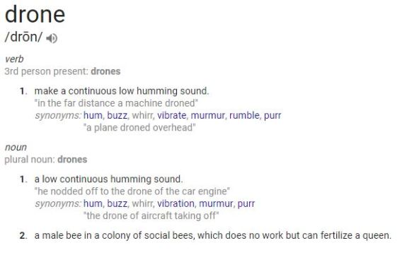
Where then did the definition of ‘drone’ come from, When was it referred to as a flying machine without a pilot on board?…
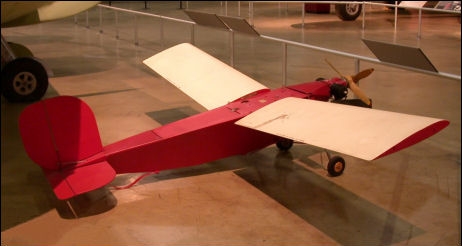
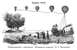
Unmanned Aircraft Systems go back before World War 1 with Balloons and Kites carrying both bombs, or camera equipment. But real Remote Control flight started with Target practice for the Airforce/Army.
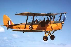
Based off a model of the De Havilland Tiger Moth 1930, DH created a straight flying Gunnery Target Drone later referred to as the “Queen Bee”
DH Tiger Moth (Trainer Plane for Fighter Pilots)
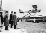
DH.82 Queen Bee (Remote Control Plane that Ground Troops Practiced blasting it out of the sky)
“Gunnery target drone”
In 1935, the DH.82 Queen Bee, a pilotless, radio-controlled variant of the Tiger Moth appeared, for use in training anti-aircraft gunners. Usage of the word drone, as a generic term for pilotless aircraft, apparently originated from the name and role of the Queen Bee Plane. Queen Bees retained a normal front cockpit for test-flying or ferry flights, but had a radio-control system in the rear cockpit that operated the controls using pneumatically driven servos, operated by a pilot using RC controlled unit on the ground.
A total of 400 were built by De Havilland at Hatfield England, and a further 70 by Scottish Aviation.[27] There were nearly 300 in service at the start of the Second World War.”
“This aircraft never turned, never pitched or rolled, and never changed its throttle position: this aircraft droned. It made a loud, low hum as it passed overhead. Drones are named for the hum, and the Queen Bee is just a clever play on words.”
The word ‘drone’ entered the US Navy’s lexicon in 1936 [4] shortly after US Admiral William H. Standley arrived back from Europe, having viewed a Queen Bee being shot at by gunners on the HMS Orion. This would be the beginning of the US Navy’s use of the phrase, a term that would not officially enter the US Army and US Air Force’s lexicon for another decade.
For nearly twenty years following the introduction of the word into military parlance, ‘drone’ meant only a remote controlled aircraft used for target practice.
Radioplane OQ-2 Wiki
We could easily burn up an entire class on the history of “Drones in the Military” . Go ahead and catch up on all this by doing a little homework on your own from the links below.
The history of drones in military and currently in every day public service.
From Predator to Phantom :
Roots/History
The Birth of the Quadcopter:
Wright Flyer: Click here for more pics of wright flyer
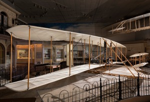

Wright Flyer Airplane. 1913 Wright Model F
More history on Wright Brothers Airplanes: Link
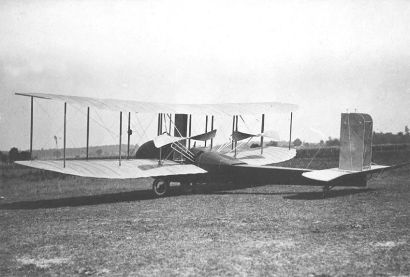
Helicopter:
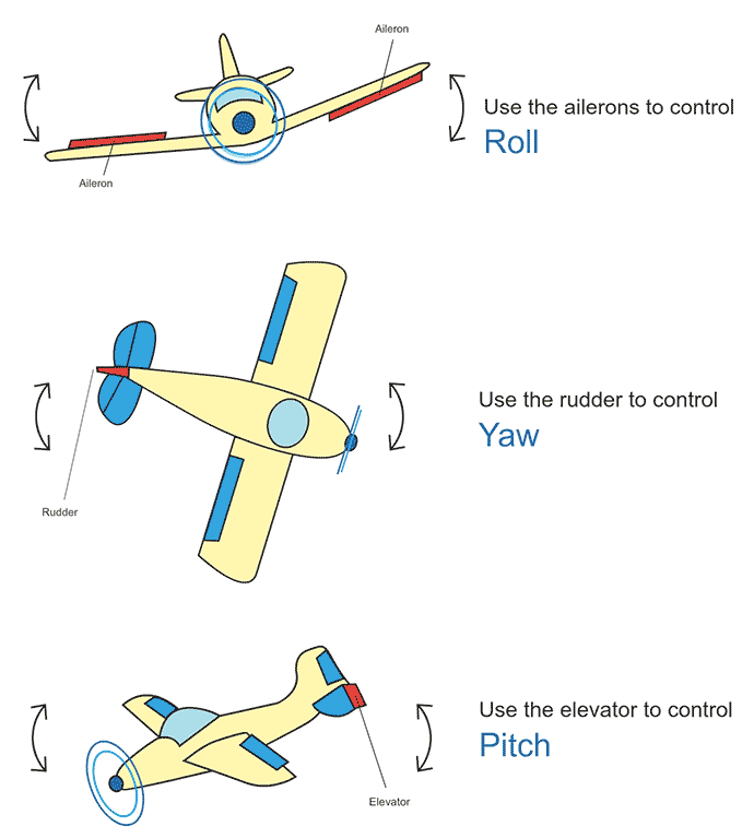
Physics of movement: Lift, Yaw, Pitch, Roll
This is a clip about remote helicopters, different from the current quad-copters, but an excellent reference for some of the earliest of trials using rotors for lift.:
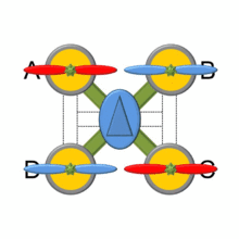
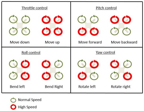
A quadcopter, also known as a quadrotor helicopter, or just a quadrotor, is a multi-rotor helicopter that is lifted and propelled by four rotors. Quadcopters are classified as rotor-craft, as opposed to fixed-wing aircraft, because their lift is generated by a set of rotors that spin propellers attached horizontally.
A quadrotor adjusts its pitch or roll by applying more thrust to one rotor and less thrust to its diametrically opposite rotor.
Radio Controlled Remote Flight, the classic controller:
hand out controllers
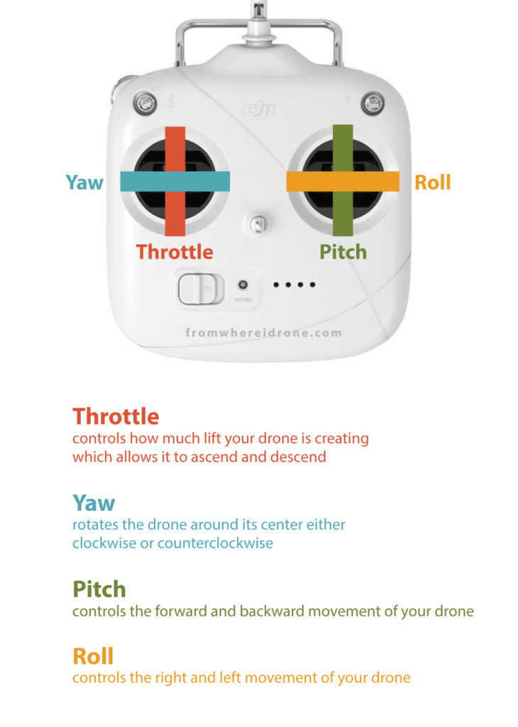
Model RC Aircraft RC Transmission History:
RC or Radio Control Flight had a big influence on where domestic and professional Drone technology is today.
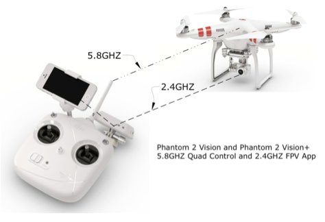
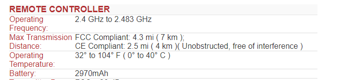
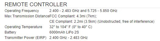
The radio transmission rates from the controller to the drone can be anywhere from 2.4ghz to 5.8ghz depending on what model you have purchased and what frequency will better fit your flying situation.
Occusync 2.0. I leave it on auto so it can find the optimal signal. In urban areas 5.8GHz can be less saturated than 2.4GHz despite the longer range.
5.8GHz is a dense wave formation that is best for carrying large amounts of data a shorter distance, while 2.4GHZ is a wider waver formation that has better penetration and distance but is not capable of carrying the same amount of data.
Occusync 4 is the latest Digital Connections Software DJI uses in consumer Drones.
The new Controllers RC2 and RCN2(with monitor) Have Occusync 4.0
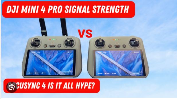
4.0 is only used on the Air 3 currently. (surely that will change)
Quick bit of info on transfer frequencies:
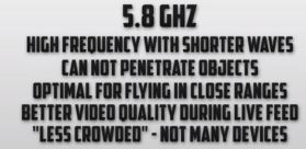
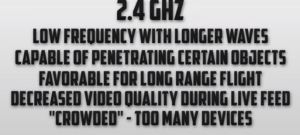
2.4ghz is a lower frequency so it’s less directional than 5.8ghz. Meaning, 2.4ghz radio waves will go around and through objects a bit better than 5.8. So if you start to descend below a building, or a bunch of trees gets in between you and the drone, etc., 2.4ghz will be a little more forgiving. 5.8 Ghz will however transmit data at faster speeds, possibly reducing latency and resulting in a higher FPV (first person view) Quality. 5.8 Ghz though, due to shorter wavelength will be more prone to interference from solid objects such as trees, tree leaves, and even raindrops. Other issues with 2.4 Ghz is that so many devices use this frequency creating increased possibility of interference. (I.E. garage door openers, microwave ovens, etc.)
Take a look at these comparisons of DJI different connections, DJI’s transmission systems-wifi/Ocusync / Lightbridge (Link Here)
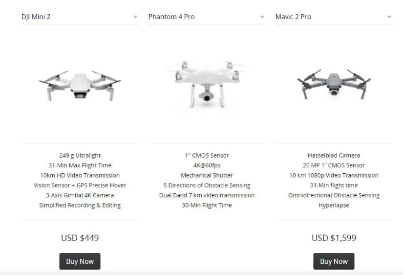
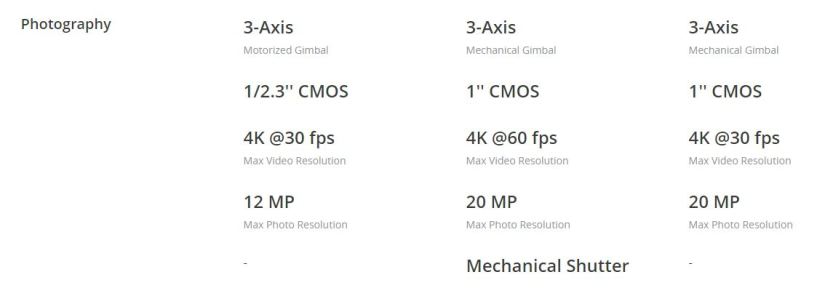
Phantom 4
Mavic 
Phantom Pro + 2.0. Advanced, The Mavic, Mavic Pro 2 and Zoom, Air, and Spark
More about transmission Frequencies using custom settings:
The Take Away:
In order to appeal to the consumer market, there was a need for smaller, quieter, and more sophisticated drone development , Advancement in transfer frequencies and GPS technology quickly came into play. This combined with state of the art microprocessors, small lightweight HD camera performance, and new software developments, this transformed into the domestic or consumer marketplace we now see today.
The Drone we see today in our consumer market place employee GPS, quite light weight high output electrical motors, operating with relatively long lasting mold-able Lithium ion batteries, and HD quality video and picture capability and on-board storage for these files. Software is the finishing touch creating an almost seamless platform from the pilot to the aircraft.
HomeWork! Please Read below:
Current state of the UAV Consumer Market Place:
UAV Technology:
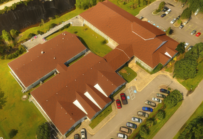
There are many types of drones on the market. With the overwhelming number of drones available, and more emerging daily there are an equal amount of companies contending with their technologies to top the list of the consumer market place. Technology for this exciting field is growing at an alarming pace. The first DJI (Phantom) Drone was was released in 2013. It was equipped with an attachment for a GoPro camera and had less then 15 minutes of battery life, and was flown with a basic radio frequency RC style controller with no display and no GPS. The Gopro was set on Record and what got captured is what you got. In comparison, the DJI Mavic will fit into your backpack, has about 30 minute flight time, With ports for displays from your mobile devices. Flight is basically on its own with the ease of GPS management on-board software, and it takes in Ultra HD 4k quality imagery that can be used in many ways personally and professionally.
Side Note: An interesting term for the new state of our daily living that is currently surrounding us: The “Internet of Things”
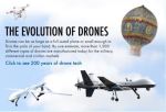
Drone timeline and the Future:
(.59)
Some interesting directions and concepts.
View this at home, in class we will demonstrate the first 1.5 minutes in class, then 5:18, and 8:08
Time Magazine cover
Super Bowl 2022 Halftime Show: Link Here
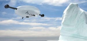
The H-Aero Aircraft, This You’ve Got to See
Here we are , Amazon starting is drone delivery services. Will we get pizza this way?
Amazon Prime Drone Delivery : Link Here
More about Delivery Drones that are already been in place: Link Here
HomeWork:
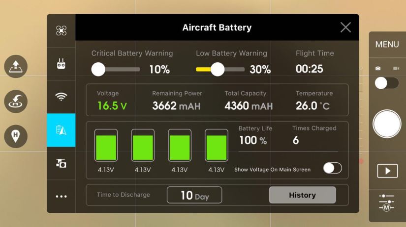
Your Drones Battery:
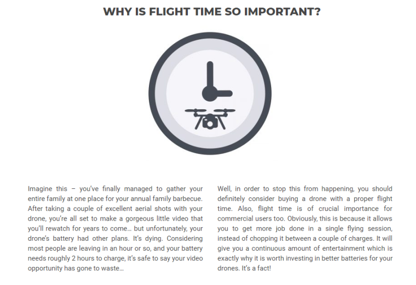
The one thorn in the field of UAS, in my opinion, is battery life. Still at a mere avg 30 minutes per flight on one charge for Both the Phantom 4 and the Mavic Pro, it really limits the true capability of this new technology tool as we use them more everyday in the fields they are destined for. Especially when it pertains to jobs that require intense purposes as search and rescue or disaster relief.
Current Long flight Commercial Drones Available:
Learn more about upcoming battery science. Link
Currently DJI drones use LiPO or Lithium Polymer Batteries.
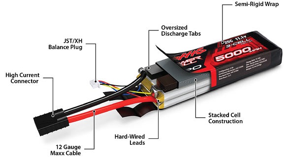
- The Lithium Polymer battery is popular because it has a high discharge rate, and the square package fits in our UAVs.
- The above cut away shows how the individual cells are stacked and wired and how the balance plug is connected to each cell.
- To achieve equal energy capacity, each cell needs to be voltage matched to the other using the balance plug during charging.
- LiPos batteries are readily available in a wide variety of sizes: Milliamp Hours per cell and Number of cells
- For our UAV use two cells to 6 cells in series and 100 to 10,000 milliamp hours are commonly available.
- Claimed life span is 600 nominal discharge cycles although reality for most is probably more like 300.
- Failure mode can be simple exhaustion, but “puffed” cells that have failed internally are not uncommon.
- LiPo batteries can also fail catastrophically from external or internal short circuit or from physical damage and burn vigorously.
- They can even burn up while just sitting there not doing anything at all, although fortunately this is less common now.
- The energy density available in LiPos can permit flights from 10 to 30 minutes in copters and perhaps up to an hour on airplanes.
Lithium Ion Batteries: Like your power tools use:
- Lithium Ion Batteries normally have at least 70 percent more energy density by weight than LiPos; This directly translates to 70 percent longer flight time (if you can use them)
- The Achilles heel of the Lithium ion battery for our use is it’s low discharge rate.
- Lithium Ion vs LiPos facts
The Drone Enthusiast: In this guide, they will talk about how to treat your batteries and make sure you get the most out of your investment. It can be the difference between getting less than 50, or more than 300 charge cycles out of your batteries!
New Battery Tech
A Short Battery life, A Drones Story: Link Here
Five new emerging Battery Technologies:
UFC FlashBatterys . Fast Charging Batteries
Lithium Metal Batteries. 70% longer lasting then Lithium Ion?
New Battery Technology: Solid State Batteries. Good look at this new and necessary emerging tech.
Get your head around Graphene: It’s the new material for the future of everything… from building materials, water filters, solar power, to batteries.
- It is ultra-light yet immensely tough.
- It is 200 times stronger than steel, but it is incredibly flexible.
- It is the thinnest material possible as well as being transparent.
- It is a superb conductor and can act as a perfect barrier – not even helium can pass through it.
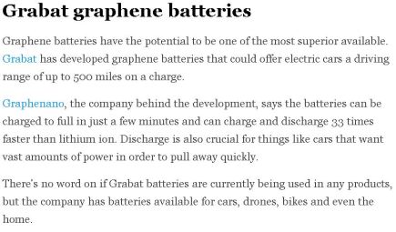
feeling xtra nerdy: read a forum post about some of the graphene batteries used in hobby/race drones. Not on market for DJI latest models, yet.
Here is More info about other Battery tech, What will we see first?
Watch this update video 2024:
Home Work: Please Read below.
Current Market Place Drones:
Good info on your typically available consumer Drones:
DJI Dominates the current consumer market place:
DJI (Dà-Jiāng Innovations Science and Technology Co., Ltd)
Latest DJI Phantom 5 Rumors. Link Here.
nov/2020 Phantom 5 update Link Here
What are the current DJI Consumer based profesional drones availble in 2024:
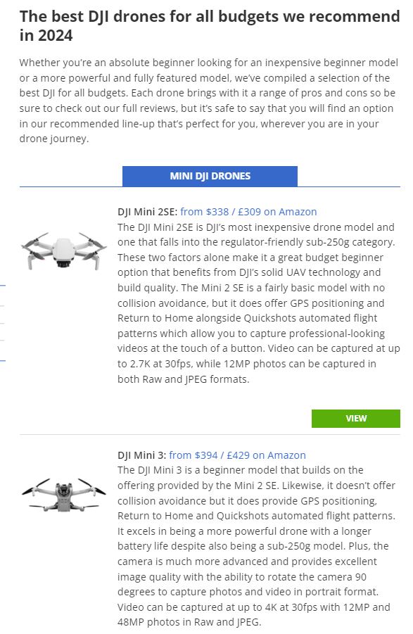
Advanced Consumer:
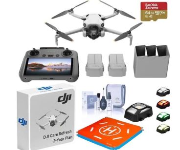
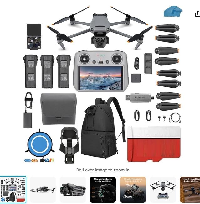
Here are links to one from the three series, mini, air, mavic with fly more kits on amazon, just so you can see what the market looks like, and what they are bundled with:
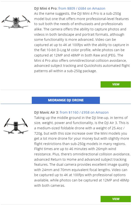
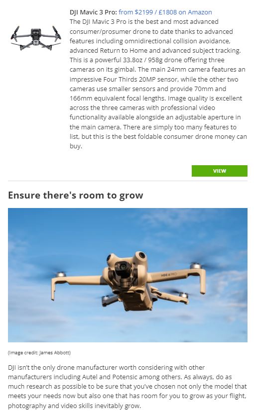
DJI Mini 4 Pro: Link Here
DJI Air 3 : (Link Here)
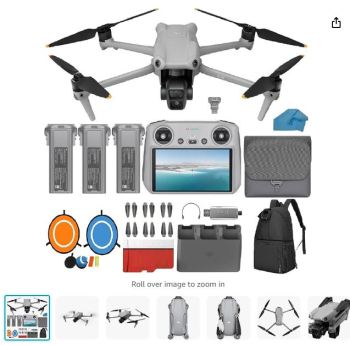
DJI Mavic 3 Pro: (Link Here)
Heres a run down of the current fleet:
Professional Grade Drones:
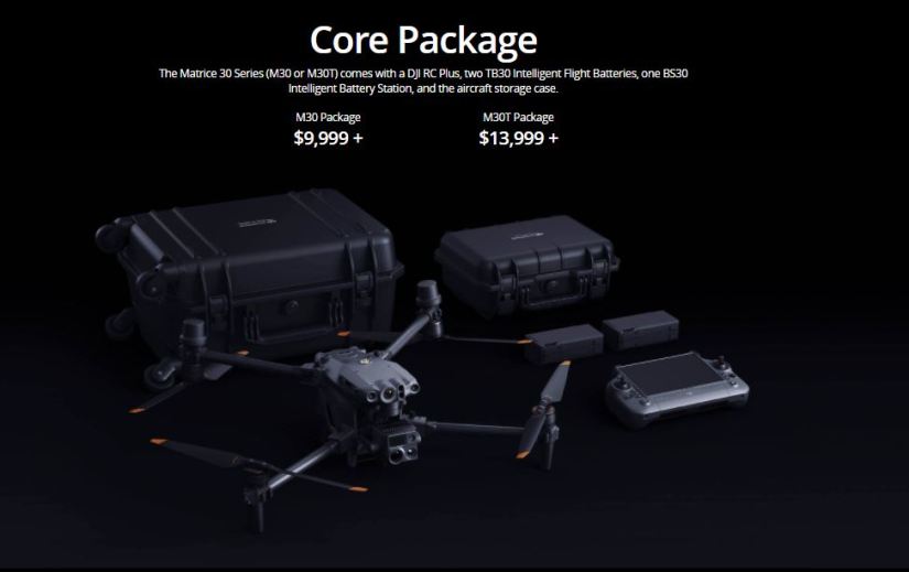
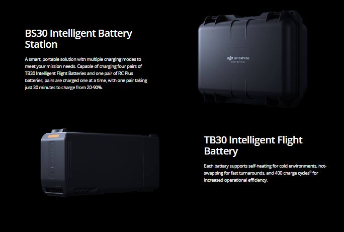
Matrice 30 Series:
Other Drones on the Market: Link Here:
LiDAR Technology:
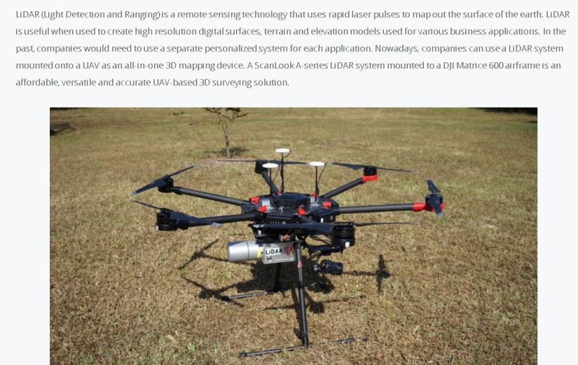
Link to more info on a DJI Matrice 600 airframe equipped with a ScanLook A-series LiDAR system
Catch up on more info about popular LiDAR Technology here
Sites to other types of drones: All unique in their own design: Link Here
Skyduo: Great Follow Drone, cheaper Alt :https://www.skydio.com/
Autel (American/Chinese) (A good competitor to the Mavic series of DJI drones)
New Autel Robotics Evo II: Link Here
Yuneec (Hong Kong) (Offering Both Commercial and Industrial Use)
3DR Solo: (affordable alternative)
GoPro: Karma (Action Sports, mini Camera) done…
Swell Pro: (Water related , Water Proof Drone, fishing, water sports, etc)
Parrot Disco FPV: (Alternative to quad copters: A winged first person viewer model, other RC vehicles)
Drone Volt (UAV solutions for Industries)
A list of different drones with features and comparisons: Link Here
Use Drone DJ.com for lots of current info on the drone market:
Which Drone is good for you?
This is a tough question, what is it that you will use your drone for? Photography, filming or both? Industrial purposes like farm, GIS/Land/Farm and construction surveying? Something quick you may need for hobby purposes? Do you enjoy or are you interested in Racing drones? Look at this :
Walk the path from cheapest to High end drones. (Always leads back to DJI:) Older vid, but leads back to Mavic 2 Pro
Here is a review of the latest and greatest DJI lineup:
Now that you have the latest UAV Hardware choices lets talk software, or in the case of drones: Apps. Most Drone related Software applications run on popular platforms that fit right in your pocket (Mobile devices/phones). Running on OS (Operating systems) like Apple (iphone) and Android (Samsung). There are many kinds of apps out there for using, utilizing, and gathering data for or from your unmanned aircraft. Software that captures, controls and performs to flight preparedness and weather. Lets break them down by categories. Drone Flight, Flight Preparedness/Weather.
Drone Flight Software:
Use this DJI page to get all the Apps DJI has to offer: (Link Here)
DJI Go 4 (Main App for managing your DJI products, flight, maintenance, and file management on your tablets/Phones: free)
DJI GS Pro (Ground Station Pro) is an iPad app designed to control or plan automatic flights for DJI aircraft: free)
Litchi (one of the most popular autonomous flight apps on the market. 19.99)
Autoflight (A complicated and expensive autonomous and semi-autonomous flight modes: 29.99)
Vertical Studio (Yet another Autonomous flight and capture app: 19.99)
3D Modeling:
Altizure (fully automated 3D mapping of an area and rendering online for a fee: free app, 3dmaps $ vary)
DroneDeploy (Another autonomous 3D rendering tool, that features Orthomosaic (meaning) , area and volume, plant health using 3D and agricultural Normalized Difference Vegetation Index (NDVI) surveying.
Drone Deploy is free to use, offering the ability to fly a set a flight pattern for your drone by mapping an area with the app, using a parameter point selection with your finger, on your device, . The drone will then take off, fly the set course and snap up to 100 or more more photos documenting your subject or area, then land where it departed.
Then using Drone Deploy’s online server, you upload the photos, and after a time : they will email you a link with your map. You then can share this data collection with others and collaborate on projects online. you get 5 maps free a month and are limited to 500 photos per upload per map. Pricing
Drone Deploy’s Resources (excellent list!)
As you can see these versions of 3d ortho-software vary in Price and can become rather expensive, the link below is an example of using open source (free) software that uses civilian drone imagery and turns unstructual data (simple photos) into structured geographic data such as colorized point clouds, digital surface models, textured digital surface models, and highly detailed orthophotography.
Of course this runs on open source platforms such as Ubuntu. (a free Open Source Operating System (os)
Students can Preview / View Map Here
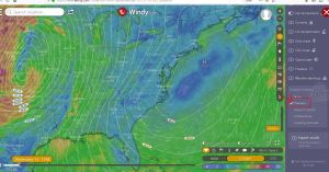
Weather: Phone or Tablet, or on the web resources:
Windy.com (on right, use more options/pressure for isobars/wind forecasts, can change layers to low clouds as well)
Windy App for mobile: Apple Android
Manteo Airport “current conditions” (hover over weather for METARS)
Albemarle Sound Marine Forecast
Wind Alert (web page at a glance you can get a “semi” accurate cloud/wind forecast)
Mikes Weather Page: (An excellent alternative to WC in Tropical Weather, redit: was)
Mr Weatherman: (This guy on Youtube does an amazing job explaining any serious cause for weather, highly recomended when things flare up down south)
Flight Preparedness:
Visualize it: FAA Date on a interactive Map: Link Here!
UAV Forecast (weather, Satellite, No Fly Zones, Restrictions: free)
Aloft: (Kittyhawk mobile apps help you get ready for a safe and successful mission. Check airspace and weather. Run a safety assessment. Get authorizations. So everyone in your fleet can fly with confidence.)
B4UFly (Is a FAA app, it has been combined with Airhub Pilot. Gives you real time airspace info and flight permissions using LAANC [low altitude authorization and notification capability) Go to the website to see Map Data in browser, or your phones store to download the Airhub Pilot App.
Sun Surveyor (want to know where the sun and its lighting is gonna be when you arrive to a flying location: 9.99)
Flight Radar 24 (Turn your iPhone or iPad into a live flight tracker and see planes around the world move in real-time on a detailed map:free lite 3.99 pro)
Flight Radar 24 (web based live radar map with real time data for most commercial flights)
Google Earth ( scout interesting locations to fly: free )
Airmap (Use AirMap to access low-altitude airspace advisories, create flights, to file digital notices, manage aircraft, & more: free)
Airnest ( plan, fly, and log drone flights: free )
DroidESB (DroidEFB is an aviation navigation app that runs on Android)
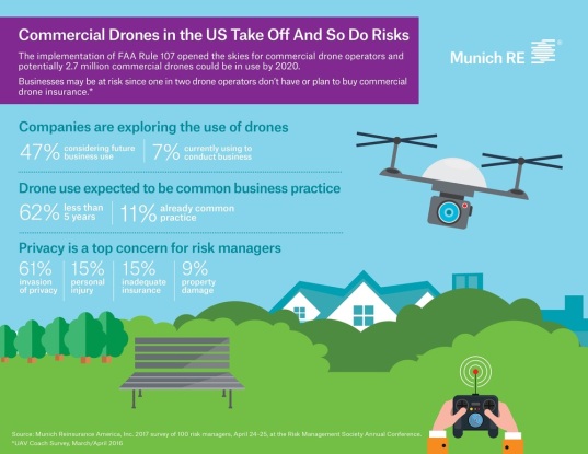
Drone Insurance : (this list put out by UAV Coach)
Verifly (gets you insured instantly, for any sized gig, for as long as you need.Hourly, daily, monthly)
Drone Related Fun:
Drone Simulator (simulated drone flight simulator)
DJI Store (exploring flying Hotspots, and easily keep yourself updated with the latest drone news: free)
Homework:
Workplace Using Drones
A look at 10 Projects that have been approved to move more “permanent presence” drones into FAA airspace. Link Here
NC DOT Photogrammetry used for transportation planning, design, construction, and maintenance.
NC DOT UAS Information. updated 2018
Great Job Source Information!
UAV Drone Jobs Great resource for using drones in the workplace
Now on with the Legalities.
Are you Flying for Fun, or Flying for Business? Basically, Are you a recreational Pilot, or a commercial pilot?
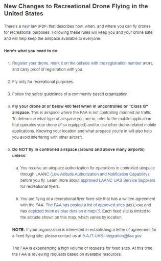
What is a Recreational Operator?
Anyone who uses UAS/drone technology solely for the purpose of recreation. (This means flying for fun, racing, or capturing aerial footage for personal enjoyment. Not for sale or services.)
Guidelines for Recreational Users
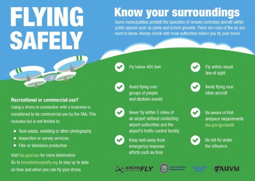
Recreational UAS operators are not required to obtain a license or permit from the Division of Aviation. However, recreational users are subject to NC UAS rules and regulations. The FAA, however, has set guidelines for safe and responsible operation:
Do you have to register your drone with the FAA if you are a hobby flyer? Yes,
Register Here! FAA Drone Zone:
- If you want to fly drones for fun in the USA, you need to take the TRUST exam (The Recreational UAS Safety Test) and carry proof of test passage when flying.
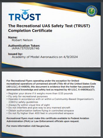
- Follow community-based safety guidelines, as developed by organizations such as the Academy of Model Aeronautics (AMA).
- Fly no higher than 400 feet and remain below any surrounding obstacles when possible.
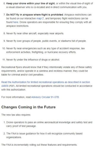
- Keep your sUAS in eyesight at all times, and use an observer to assist if needed.
- Remain well clear of and do not interfere with manned aircraft operations, and you must see and avoid other aircraft and obstacles at all times.
- Do not intentionally fly over unprotected persons or moving vehicles, and remain at least 25 feet away from individuals and vulnerable property.
- See LAANC info listed below.
- Do not fly in adverse weather conditions such as in high winds or reduced visibility.
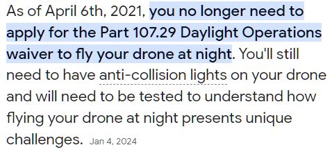
- Do not fly at night. Has changed:
- Do not fly under the influence of alcohol or drugs.
- Ensure the operating environment is safe and that the operator is competent and proficient in the operation of the sUAS.
- Do not fly near or over sensitive infrastructure or property such as power stations, water treatment facilities, correctional facilities, heavily traveled roadways, government facilities, etc.
- Check and follow all local laws and ordinances before flying over private property. (FAA has stepped in)
- Do not conduct surveillance or photograph persons in areas where there is an expectation of privacy without the individual’s permission (see AMA’s privacy policy).
- Do not fly near emergency response efforts such as fires or hurricane recovery efforts.
- Do not fly for compensation.
- Must be over 13 years of age
- Do not fly a UAS/drone that weighs more than 55 pounds.
- If a drone needs to be registered, it must have standard remote ID, a broadcast module, or a operate in a FRIA. What is a Fria? Click that link to the left.
FAA-Recognized Identification Areas can be found Here:
What is a Commercial Operator?
A person or company using UAS technology for compensation or business purposes. This includes any person or company using a drone in any way to advertise, promote or demonstrate a product or service – even if the product or service itself does not include a UAS, UAS-derived photography, etc.
For example, if a real estate agent uses a drone to photograph a property in order to advertise or promote that real estate for sale or lease, then that UAS operation is commercial: the UAS was used for business purposes. You will need the 14CFR part 107 small unmanned aircraft system certification.
Federal Restrictions & Requirements
- Commercial UAS operators can operate under 14 CFR (Code of Federal Regulations) Part 107, also known as the Small UAS Rule, as of August 29th, 2016. Under this rule, the person operating a small UAS must either hold a remote pilot airman certifcate with a small UAS rating or be under the direct supervision of a person who does hold a remote pilot certificate (remote pilot in command).
- You’re a U.S. citizen, a legal permanent resident, or legal visitor
- You will label your drone with your own unique registration number
- You pledge to have read and understood all the safety guidelines
- You must be 16 yrs of age
- Drone must weigh .55lbs to 55lbs. Any thing else requires a FAA Waiver.
- 4. You need to have authorization using LAANC or DroneZone before flying at or below FAA-authorized altitudes in Class B, C, D, and E controlled airspace.
Information for Waiver process for the FAA: Link Here
Waiver examples: These Waiver are going to be waived, as part of commercial Pilots carrying Part 107 new refit.
- Flying at night in controlled airspace under 400ft (Part 107.29)
- Flying directly over a person or people (Part 107.39)
- Flying from a moving vehicle or aircraft, not in a sparsely populated area (Part 107.25)
- Flying multiple aircraft with only one pilot (Part 107.35)
- Flying beyond the pilot’s visual line-of-sight (Part 107.31)
- Flying above 400 feet (Part 107.51B)
- Flying near airports / in controlled airspace (Part 107.41)
Drone Registration
From the FAA: New Regulations instated
Effective August 29, 2016 the Federal Aviation Administration’s (FAA) new comprehensive regulations went into effect for routine non-recreational use of small unmanned aircraft systems (UAS) – more popularly known as “drones.”
From the FAA: Guidelines for UAS use
“Unless exclusively operated in compliance with Section 336 of Public Law 112-95 (Special Rule for Model Aircraft), the aircraft must be registered if over 0.55 lbs.”
Not relevant of dec 2017:
“FAA Registration Deletion update:
What does it mean in a nut shell. If you registered your Drone because it was greater then .55 lbs. You did what they first required, and now they are suggesting you register voluntarily on your own.”
Now as of Dec 2017 the FAA has doubled back and you now have to register your drone if it is above .55lbs
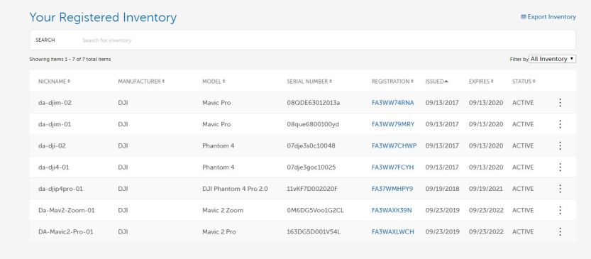
FAA Drone Registration and account information.
Failure to Register Your Drone as a Commercial Part 107 Certificate holder.
If you’re tempted to put your UAS registration on hold—think again. There can be serious consequences for those who fail to register their drone. Civil penalties can reach as much as $27,500.
Under 18 U.S.C. 3571, there are even harsher consequences for criminal penalties. These can include hefty fines to the tune of $250,000 and/or incarceration for anything up to three years.
Drone Rules for Visitors in the US
Visitors to the US can legally fly drones and other types of small unmanned aircraft under the same guidelines as nationals. That means they also have to register their UAS on arrival [6].
A PDF That Explains some common sense answers in whats in this new Bill.
FAA UAS Data Exchange :
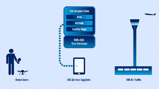
LAANC is the Low Altitude Authorization and Notification Capability, a collaboration between FAA and Industry. It directly supports UAS integration into the airspace.
If your area is equipped with LAANC, then you would apply through a smart phone app such as AirMap. They are only able approve flights up to 400’ AGL. If your area is not equipped with the LAANC system, or you wish to fly beyond 400’ AGL, then you will need to call the Air Traffic Controller in your area for authorization. To see what areas are currently equipped with LAANC, as well as the estimated date of addition, go to: https://www.faa.gov/uas/programs_partnerships/uas_data_exchange/.
Heres another article if your interested in new rules flying near airports: Link
DJI Fly Save Geo Zone map (clear your drone to fly in a restricted area.)
North Carolina Restrictions & Requirements
Fantastic Link for NC Rules regarding Drones. Link Here
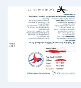
- Commerical UAS/drone operators operating under 14 CFR Part 107 or a 333 Exemption within North Carolina are required to have a valid NC UAS Commercial Operators Permit.
- Commercial operators must take and pass NCDOT’s UAS Knowledge Test and then apply for a state permit.
- To obtain a permit, operators must provide the state proof of their remote pilot certificate or other authorization to conduct commercial UAS operations from the FAA (see Federal above).
- Permitted operators agree to these Terms & Conditions.
NC State Regulations :
The State NCDOT website (link) has guidelines for both Recreational and Commercial use of UAS .
NCDOT requires, if you are using your drone for commercial or government operation, you must hold a “NC Operator Permit”, obtained by taking and passing the online knowledge test, then apply online for the permit, print the permit and carry with your NC Drivers License when operating your uas.
(I took the knowledge test, cold with no studying and got a 90%, mostly common sense questions about violations pertaining to operating the drone for misuse. “like unauthorized surveillance, private property flight and retrieval, and messing with wildlife or legal hunters.”)
I would suggest having this even if you plan to remain a recreational user. Though it is not required by the state of NC.
Local Drone Ordinances: Dare County:
Dare County Website list two restrictions besides repeating the aforementioned NC Restrictions.
Nags Head: (list a FAQ and a town ordinance that states: Operation of small unmanned aircraft on or over the ocean, beach and the State’s
estuarine waters, is prohibited from 9AM to 7PM from the start of Memorial Day holiday
weekend to the end of the Labor Day holiday weekend, without prior written approval from the
town manager. ) (Check Links below) Does Not apply Now… Here is whats on their site as of now:
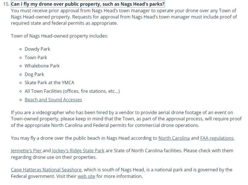
Operation of small unmanned aircraft on or over public property is prohibited without
prior written approval from the town manager. )
Can I fly my Drone over my neighbors house? This is a messy subject to dig into for most non- legal professionals, but for drone operators the law’s vagueness presents issues on a daily basis. From the property owner’s perspective, there are privacy and ownership issues to be considered and from the FAA’s viewpoint there are concerns about air traffic and public safety. Both sides have legitimate interest for safety and privacy and they are both closely monitoring the drone industry. Easy answer is:
WE ENCOURAGE DRONE PILOTS TO BE SAFE, USE GOOD JUDGEMENT AND BE RESPECTFUL AS A RULE. IT IS ALWAYS GOOD PRACTICE TO NOTIFY PROPERTY OWNERS BEFORE FLYING OVER THEIR PROPERTY IN ORDER TO AVOID UNNECESSARY CONFLICT.
Article 1 Can I legally Shoot Down a Drone?
Article 2 When a Drone flys over my house , is it trespassing?
Article 3 Who owns the air above my home?
Article 4 Do neighbors have rights to fly camera toting drones over my house?
These have changed as a Part 107 carrying pilot you can do these things but because you can, should you?
So you cant fly over Dowdy Park while there are kids running around? No Flying over the beach while people are sunbathing? No, flying over any body is prohibited by FAA Regulations as stated above. Use Common sense, and know the laws.
Update
This has been recently updated per FAA claiming local ordinances do not control federal airspace there for can not apply their local ordinance in Federal Space….
Local Drone Law Struck Down by Federal Preemption (first case, sept-2017)
More info Locally sept 9 18
State and National Parks
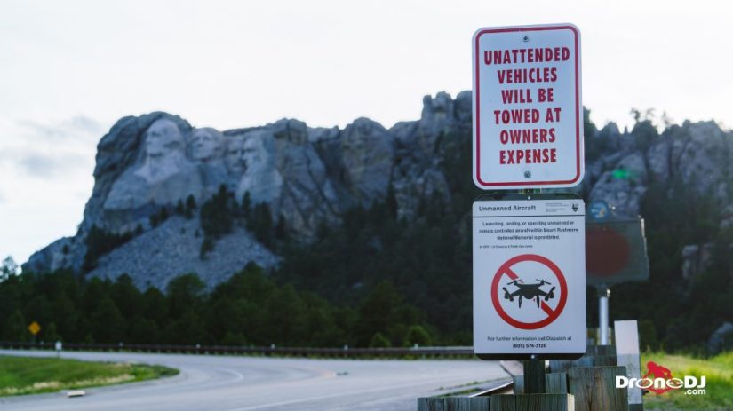
Drones/UAS are prohibited in National Parks
Launching, landing, or operating an unmanned aircraft from or on lands and waters administered by the National Park Service within the boundaries of Cape Hatteras National Seashore is prohibited except as approved in writing by the superintendent. This includes the Bodie Island Lighthouse, Cape Hatteras Lighthouse, Wright Brothers National Memorial, Fort Raleigh Historic Site, Pea Island and beaches of the Cape Hatteras National Seashore. The term “unmanned aircraft” means a device that is used or intended to be used for flight in the air without the possibility of direct human intervention from within or on the device, and the associated operational elements and components that are required for the pilot or system operator in command to operate or control the device (such as cameras, sensors, communication links). This term includes all types of devices that meet this definition (e.g. model airplanes, quadcopters, drones, model rockets) that are used for any purpose, including recreation or commerce.)
(Could only imagine some permit use in the future, as our National Parks are a public treasure and with proper suas education and management, would be a nice PR tool to share the beauty.update 2018: Not likely to Happen…. lol)
NC State Parks, Same as Federal
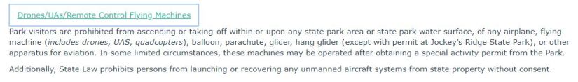
Just follow these guidelines:
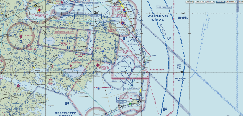
Visualize it: FAA Date on a interactive Map: Link Here!
Sky Vector- Check out these Vector sectional Charts.
Next Class 4/24/18
We will review the details of the exhausting Study Guides and Try and tame the “Endless Stream” of online info pertaining to the 14CFR part 107 small unmanned aircraft system certification needed for business done with your SUAS (drone)
Special Thanks To Current TV Dare
LDPI Grant: Local Programming Development Initiative